Images of mills and the Albolafia of Córdoba

In the course of the Guadalquivir River along its passage by Córdoba, and next to the Roman Bridge, we find some mills and waterwheels of a very singular character, whose origins give us idea of the raison d’être of the city in connection with the river. Their image has played a key role in the making of the landscape of Córdoba throughout its history, as it appears in the main views of the city that have been drawn since the 16th century until our days, some of which are presented in this article.

View of Cordoba with the Roman bridge and the Guadalquivir River. Postcard published c. 1905, and recent photograph.


BRIEF HISTORICAL NOTES

According to diverse research on waterwheels, their origins are placed in Eastern Mediterranean towards the 1st and 2nd centuries BC. The first notices about the existence of horizontal waterwheels are to be found in the year 85 BC. Vitruvius described around the year 27 BC the hidromolae (or hydraulic mill), whose basic structure has survived to the present day although such a type would have coexisted with other wheels moved by animals or even by slaves.

Around the 10th century we find the first references to waterwheels used to irrigate the gardens of the residence built by Abd Allah (888-912) in the city of Córdoba.
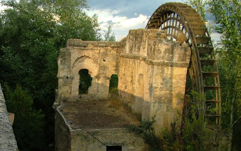
Current state of the Albolafia Mill, inside de bed of the Guadalquivir River, and close to the Roman Bridge that leads to one of the entries in this historical city. ©AramcoWorld. Dick Doughty
According to an Arab chronicle found by Leví Provençal, the great waterwheel by the bridge was built around 1136-1137 by emir Tashfin, the Almoravid governor of Córdoba. It was to be named the “Albolafia”, which can be translated as “the good luck one” or “the good health one”.

There is also information from the 10th century about the mills that shared the azuda or the dam with the Albolafia.

Al-Idrisi describes in the first half of the 12th century a dam over which there were three buildings each with four mills. Later, al-Himyari describes again the existence of a pier built of cut stone, downstream from the bridge, whose aim was to prevent the erosion of the riverbank, and it supported three mills, each with four grindstones.

The first Christian mention to those Cordoban constructions dates from 1237, when Ferdinand III granted to Don Gonzalo, bishop of Cuenca, Don Tello Alphonso and Don Alphonso Téllez four flour mill wheels, located at the “azuda of Culeb”, as the place could have been named in Muslim times.  In 1492, Isabella II ordered the the wood wheel of the Albolafia to be disassembled, because its “rhythmic squeaking” or “repetitive lament” kept her sleepless when she inhabited the Christian castle in the hot month of June. Years later, chronicler Ambrosio de Morales (1513-1591) reveals to us his astonishment by observing “that superb building, now named the Batán (hydraulic machine) of the Albolafia”. Between 1574 and 1588 the nuns of Jesus and Mary owned the wheel of the Albolafia, and they carried out restoration works directed by Juan de Ochoa, the headmaster of the constructions works in the city. According to these documents, it can be underlined that some mills had more than one wheel, sometimes with different tenants, although their ownership was unitary. There are interesting references related to the donation of wheels to the church (with its corresponding part of the channel in the Guadalquivir River) in exchange of a privileged place of burial or masses in memoriam.

Its possible use as factories for paper is an appealing issue but poorly documented, mainly in caliphal times, when a given author identifies the mills of the azuda, under the Roman bridge, as paper mills. It is known that the techniques of papermaking were to arrive soon from the East to al-Andalus, and there is information about the impressive Cordoban libraries, like that of al-Hakam II, which had around four hundred thousand books, or that of Ibn Futais (a whole building with corridors, staircases and shelves filled with books…), which suggests the existence of such industries for the making of paper. Notes about a paper factory also appear around the 18th century, according to which it was in the second azuda under the Roman bridge, next to the current bridge of San Rafael, which disappeared due to the scarce quality of the paper produced, which was not white enough.


LANDSCAPE IMAGES OF CÓRDOBA
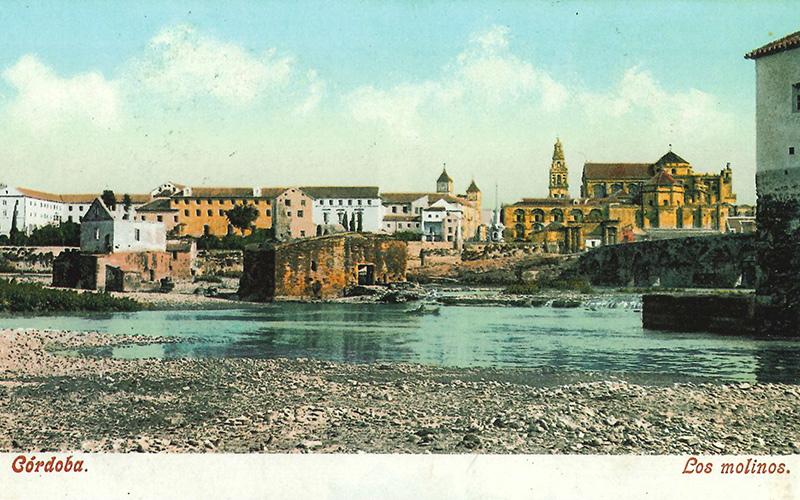
View of Cordoba with the Roman bridge and the Guadalquivir River. Postcard published by Purger & Co. c. 1905.
After tracking through a vast bibliography to obtain significant images of Cordoba from the last five centuries, it should be noted that the city has an important legacy of landscape views. Many of them are little known, but other have been repeatedly reproduced and have been of great importance for getting to know the city and for the dissemination of its image beyond our borders.

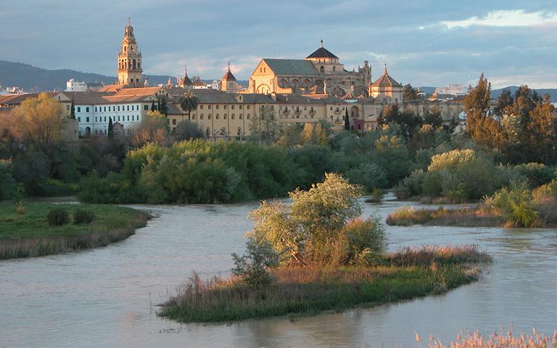
When we reviewed them all, we can observe how Córdoba has been always drawn, photographed, and immortalized mostly from the left riverbank, framing its most photogenic profile: with the Guadalquivir River and the Roman Bridge in the foreground, the mills and the Abolafia alongside, with the mosque and the historic quarter behind, and Sierra Morena in the background. Given the great number of images available, we will only reproduce some of them here, only referring to the closer details and its immediate surroundings, considering that their analysis can lead to a wider and more open research.

FIRST IMAGES

One of the first known representations of waterwheels is the one that appears in a stamp of the city from 1357, showing its main features in an idealized form. In the background appear the mosque with its Islamic minaret, its roofs, and the Patio de los Naranjos (Courtyard of Orange Trees). In the foreground and middle ground appear the river and the wheel of the Albolafia, in an exaggerated size in relation to the Roman Bridge, maybe to highlight its historical importance.

One of the most important images of Córdoba along its history is the one drawn in 1567 by the artist Anton of Wyngaerde, painter in the service of King Philip II. It is included in an excellent collection of views of cities practically unknown until they were published in 1986. The drawing includes abundant details of a great credibility, which adds a documental value to it. In the foreground stand the buildings of the left bank, where the Saqunda quarter was, inhabited by merchants and artisans in al-Hakam I’s times. This was to be raided and razed, and later used as a cemetery, until the end of the 15th century, under the name of Campo de la Verdad (Truth Field), where the Arrabal de los Corrales (Quarter of the Farmyards) arose. Small vessels also appear, sailing between the mill of Martos and the Roman Bridge, at the so called Tablazo de las Damas, a place where bathing and boating was common. Downstream from the bridge the Abolafia and the three mills known today as Don Tello’s, (or Pápalo Tierno) Enmedio’s (Of the midst) and San Antonio’s are also drawn. Even then the thick vegetation of its surroundings, today known as Paraje Natural Sotos de la Albolafia (Natural Area Sotos de la Albolafia) was highlighted. The three mills show a single floor and vertical wheels, but the Albolafia appears without its wheel, which was disassembled in 1492 as we have already said. The drawing also details with great precision the architectural elements (stairways, boreholes, even fishing gears), whose information matches drawings that came after them or photographs from the 20th century.

Another engraving depicting Córdoba is included in an important collection containing around 540 views of cities of the world, known as Civitates orbis Terrarum, in its Volume VI, dated 1617. This view had a huge international impact, for there were many of these works in various languages and diverse copies made in the 17th and 18th centuries that are less known (Meisner, 1625; Van der Aa, 1707). Nevertheless, without diminishing the engraving, it is easy to see that the view is less reliable and precise than the drawings of Wyngaerde. In San Antonio’s mill, its vertical wheel has disappeared, its access switched from the right bank. The Albolafia is not drawn, maybe by mistake, and the existence of abundant vegetation is again featured.
VIEWS FROM THE FIRST HALF OF THE 19TH CENTURY 
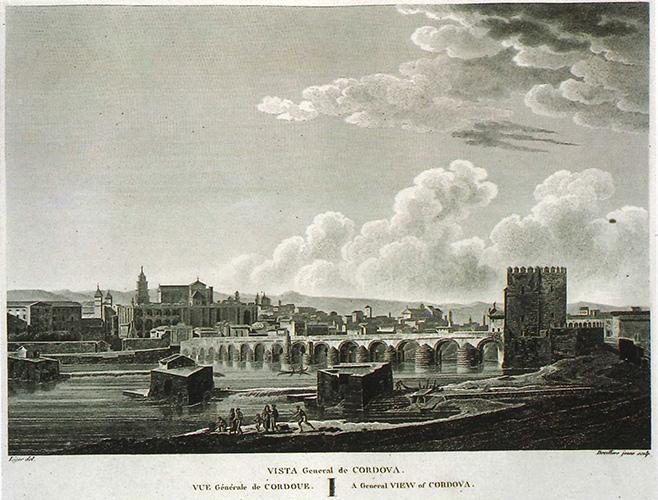
The bridge and the Guadalquivir River. Engraving published by Alexandre Laborde in 1812.
The outstanding publication of Voyage pittoresque et historique de l’Espagne (A Picturesque and Historic Voyage in Spain) by Alexandre Laborde, contains in its Volume II (1812) 21 views of Cordoba drawn with a great rigour and precision. One of them shows the bridge and the other three mills, though still with only one floor. The azudas or dams are drawn, as well as the spillway floodgate located by the entrance to San Antonio mill. Also, we can see the quartering of the stone bank that led to the mill from the shore, the small stone access bridge, and a small platform over which its construction was enlarged later. In the mill of Enmedio, we can see a stairway that rises from the water, probably to provide access from boats, or even to get up there on foot in dry seasons. In the same way, it details a small room atop the place for spare parts, the storeroom or warehouse where wheat was kept before being ground.
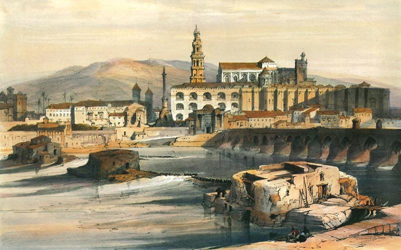
The bridge and the Guadalquivir River. Hand-coloured lithograph, drawn by David Roberts in 1832 and published in 1837.
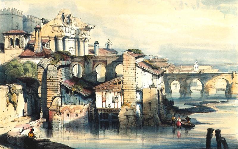
The Albolafia. Hand-coloured lithograph, drawn by David Roberts in 1832 and published in 1837.


The David Roberts drawings, dated in January 1832 served as the basis for the beautiful lithographs and engravings that were published few years later. This famous Scottish traveller and architectural painter sometimes manipulated his views masterfully for purely pictorial reasons; therefore, his beautiful drawings must be analysed with caution. In a view of the bridge and the mosque in the background, we can see in the foreground the abandoned state of the three mills, which have definitively lost their vertical wheels. On the side of the central mill, we can see the half-pointed arch next to the place that occupied the wheel and the point where the axis penetrated the room that hosted the grinding machinery. The mill of Pápalo Tierno presented a growth in its buildings. In the façade of the mill of San Antonio, a niche with a small image on a wooden lintelled door can be seen, and on its left side there is a small window aperture.

The composition of this façade has been maintained throughout the expansion works of the mill, as shown in postcards from the beginning of the 20th century.
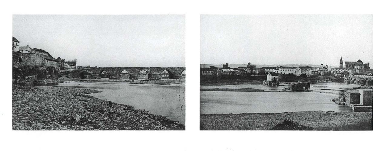
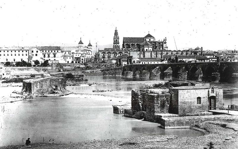
The bridge and the Guadalquivir River. Photograph by Jean Laurent, c. 1867.
Also, it is clearly depicted how the azudas or dams were executed with piles set vertically and interspersed with earth, rather than being built with a solid masonry work, as it was done in the mills of Martos or Don Lope, both located upstream.
The bridge and the Guadalquivir River. Photograph by Lucien Lévy, 1888.
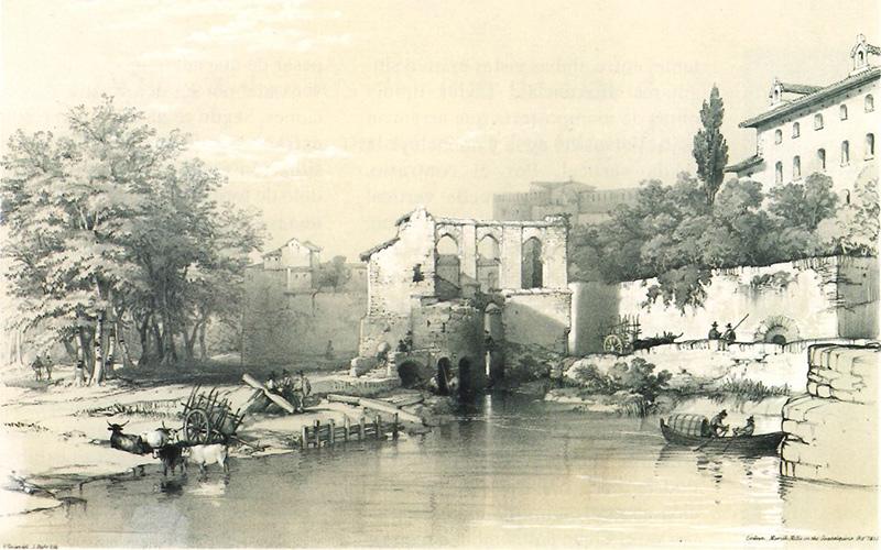
It is of a great interest to compare another view of the Albolafia published by Roberts, which has been studied by several scholars, together with a less known one published by Baron Taylor shortly earlier (between 1827 and 1832). Both documents show accurately the state of the building from an unusual point of view, downstream with the bridge in the background, showing the road built by Abd-er-Rahman II in the year 827, and the gate named Bab al-Sudda he also built, which was demolished in 1822. Its name reveals that there was a sudda or sud, azud or azuda, a dam to raise the river level alongside the waterwheels or mills. This gate was connected to the Albolafia by means of big arches whose feet can be seen in these views, which were studied by Gómez Moreno in 1906. Both images show walls pierced by horseshoe arches which extend over the river to find the greater volume of flow for the wheel. Nevertheles, there are singular differences between both views. Taylor’s drawings show masonry works done under the water level without the vertical wheel being included. On the contrary, Roberts did draw a vertical wheel that seems to be a mill wheel   ̶ smaller than that of the current Albolafia ̶, to raise water up to the canal located between both mentioned arches. Moreover, the building drawn by Roberts based on a wooden structure built on piles is highlighted, while Taylor did not include it. The accuracy of Roberts’s drawings of such a structure might lend credibility to that solution, uncommon in the building of mills in the Guadalquivir River. Yet, a picture by J. Laurent, dated to the second half of the 19th century, corroborates that the structure built on piles did not exist, in spite of the drawn by Taylor that is less plausible given its distorted proportions. As it is said, it was not unusual for Robert to manipulate the real features of the building by idealizing it in a pictorial way and inventing a wheel that does not appear either in view of Vivian mentioned later.
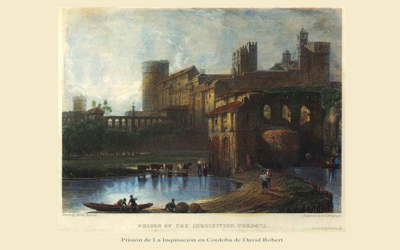
The Albolafia and the Alcázar. Engraving, drawn by David Roberts in 1832 and published in 1836.
An engraving based on another drawing by Roberts, with the title “Inquisition’s Prison” shows the river, the Albolafia and the citadel as background. The area of the mills has been historically connected to deaths and executions, and the bodies of the executed were exhibited there since the times of the Caliphate. In Christian times, the unfortunates who were condemned by the Inquisition would have been burnt on the islets next to the bridge. In the forefront of the drawing, we can see people walking on the pier, amid boats and fishermen’s pots.  Although that information agrees, as do the architectural features of the Albolafia, with other authors, the surrounding landscape (gardens, walls, towers, aqueducts…) seems to have been boldly reinterpreted.
Another exquisite view from the bridge, by the artist from London George Vivian, was published in 1838 that shows accurately its details. In the lower part of its central arch there is a small bridge that allowed the passage from the causeway promenade to the islets which had a lush vegetation. The piles set in the soil to contain the water appear drawn, and the absence of the vertical wheel is notable, in relation to the view by Taylor we have mentioned before. Although it would have been common that engravings of the time include imaginary people to create the ambience of the place, the fishermen who were drawn in this case are quite credible, as it is known that these channels called “fishery channels” were rented near the mills for that use.


THE ARRIVAL OF PHOTOGRAPHY TOWARDS 1850

The panoramic view by architect Alfred Guesdon, drawn around 1853-1855, a pioneering representation of the city of Córdoba taken from an aerial point of view, has a great documental precision. It was surely obtained by using early pictures taken from an aerostatic balloon, according to an article published by Gámiz Gordo and García Ortega (2018).  Its framing includes views of the river and its mills in the foreground, with the walled city in the background, which verifies the accuracy of its details and is in agreement with those appearing in former images. In this way, in the river’s islets we can see the leafy poplar grove that housed the causeway promenade that surrounded the citadel wall, and the buildings around the Albolafia described in detail.

New graphic testimonials by diverse photographers multiplied in the second half of the 19th century. Among them, the panoramic view by Laurent stands out, which includes the whole bridge and the building of the Albolafia, whose configuration matches with the aforementioned engraving by Taylor. In the other end of the panorama, Don Tello’s mill appears, amplified with one more floor that rises over its original structure.
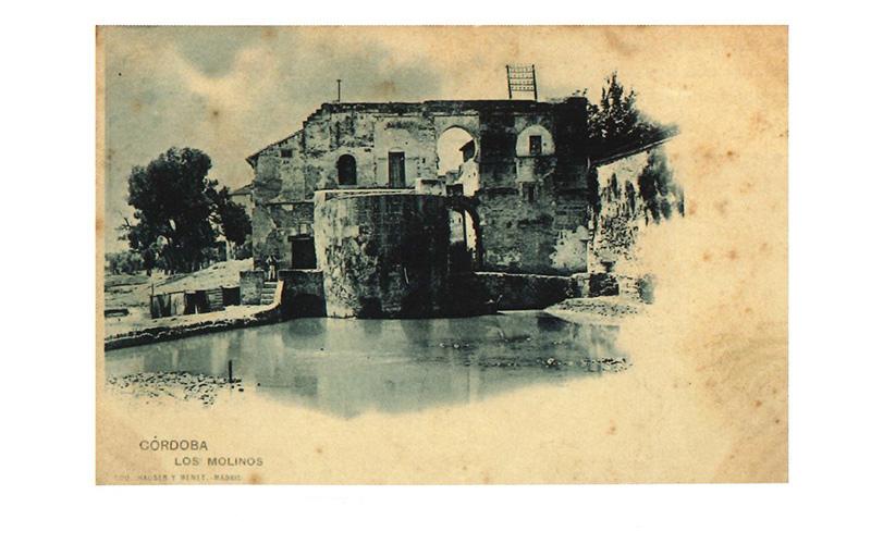
The Albolafia. Postcard published by Hauser and Menet c. 1900.
Since 1895, Hauser and Menet, and many others after them, published photographic reproductions in postcards, including the Albolafia and the mills. They show the different interventions that prove the continuity of their use. Hence, postcards dated towards 1905 show the mills of Don Tello and San Antonio with one more floor. The latter was enlarged, occupying the esplanade that was next to its access, with a new façade that repeats identically the original one. Nevertheless, the mill of Enmedio, with a more complicated access from the shore, shows already the dilapidated state which has continued until our day.
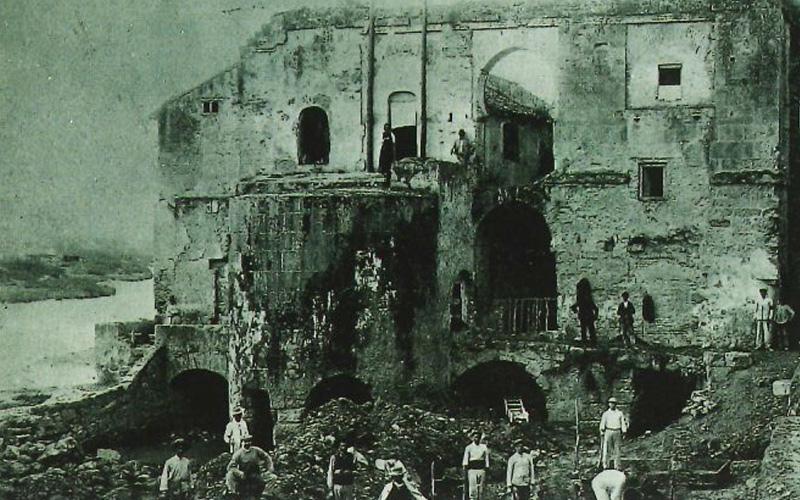
The Albolafia. Anonymous photograph c. 1905. Espasa archives.
Finally, it is worth stressing that a picture by an unknown author, from the archive of Espasa from 1905 is mentioned here, where the excavation and consolidation work of the Albolafia can be seen. The construction elements are shown with a special accuracy, especially the body of the building that was demolished towards 1950 on the occasion of the construction of the ring road located along the right bank of the Guadalquivir River.


By:

Antonio Gámiz Gordo, Ph. D. Architect, University of Seville
Diego Anguís Climent, Ph. D. Architect, University of Seville
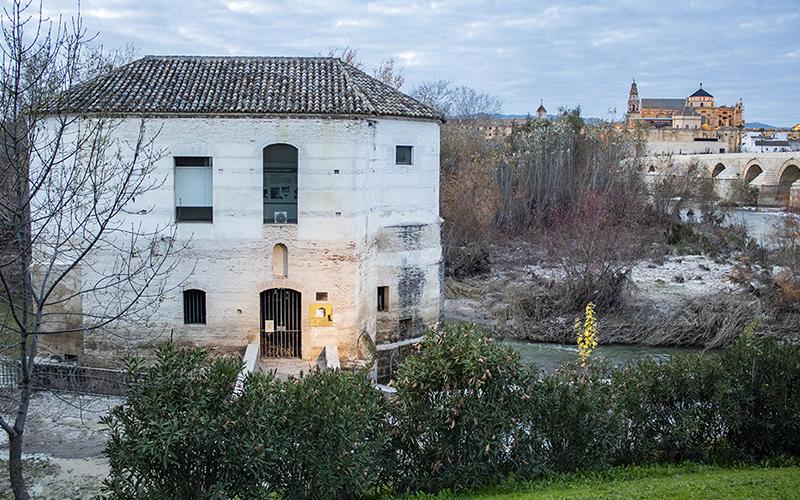


Current View of mill of San Antonio on the left, and right vegetation in the river .


Share This